
Neil Cowley

Introduction
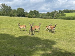
Monitoring deer populations is essential for conservation, land management, and ecological balance. Traditional counting methods, such as ground surveys and camera traps, can be time-consuming, inaccurate, and disruptive to wildlife. However, advancements in drone technology have revolutionized wildlife monitoring. A thermal drone survey provides a non-intrusive, efficient, and highly accurate way to count deer populations across the UK.
In this blog, we’ll explore the benefits of using a deer drone survey, how thermal imaging enhances accuracy, and why this method is becoming the preferred choice for wildlife researchers and land managers.
Why Use a Thermal Drone Survey for Deer Counting?
1. Enhanced Accuracy and Efficiency
Traditional deer surveys rely on direct observation, which can be hindered by dense woodland, poor visibility, and animal movement. Thermal drones detect the heat signatures of deer, allowing for precise population counts, even in challenging environments. Unlike human observers, thermal drones can cover vast areas in a fraction of the time.
2. Minimising Disturbance to Wildlife
Conventional survey methods often involve human presence, which can disturb deer and alter their natural behavior. A drone survey for deer eliminates this issue by capturing data remotely, reducing stress on the animals and providing more natural insights into population dynamics.
3. Effective in Low-Light Conditions
Deer are often most active during dawn and dusk when visibility is limited. Thermal imaging allows surveyors to detect deer regardless of lighting conditions, making it a superior method for deer drone surveys.
4. Cost-Effective and Scalable
Deploying a thermal drone survey reduces the need for multiple fieldworkers and expensive tracking equipment. The ability to quickly survey large areas makes it a scalable solution for estates, conservation projects, and scientific studies.
How a Deer Drone Survey Works
Step 1: Planning the Survey
Before deploying a drone, surveyors assess the landscape, weather conditions, and the best times to conduct the flight. UK regulations require drone pilots to follow Civil Aviation Authority (CAA) guidelines, ensuring safe and legal operations.
Step 2: Deploying the Thermal Drone
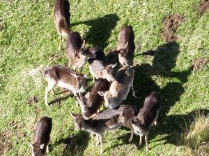
A drone equipped with a high-resolution thermal imaging camera is flown over the survey area. The camera captures infrared heat signatures, distinguishing deer from their surroundings.
Step 3: Data Collection and Analysis
The thermal data is processed using specialised software to count individual deer and analyze their distribution. Advanced AI tools can differentiate between species, identify movement patterns, and provide valuable insights into herd dynamics.
Applications of Thermal Drone Surveys in Deer Management
1. Conservation and Population Monitoring
Wildlife organisations use thermal drone surveys to monitor deer populations, ensuring they remain at sustainable levels and do not negatively impact biodiversity.
2. Deer Impact Assessments for Landowners
Landowners and estate managers can assess deer numbers to manage grazing pressures, protect woodlands, and prevent overpopulation.
3. Reducing Human-Wildlife Conflict
By accurately tracking deer populations, conservationists can implement targeted management strategies, reducing conflicts with agriculture and forestry.
Conclusion
Using a thermal drone survey for deer population monitoring is transforming wildlife research and land management. With enhanced accuracy, minimal disturbance, and cost efficiency, this technology is becoming the gold standard for deer drone surveys in the UK.
If you’re looking to conduct a drone survey for deer, consider partnering with professionals experienced in drone-based wildlife monitoring. Investing in cutting-edge technology ensures precise data collection, aiding conservation efforts and responsible deer management.
Would you like to learn more about how a thermal drone survey can benefit your estate or conservation project? Get in touch today!